Log in
All resources
Create a design
583 Free Images of 1865 Maps
gemeente atlas van nederland - north brabant
jacob kuyper
gemeente atlas van nederland - utrecht
history
historical
gemeente atlas van nederland - drenthe
charleroi on maps of popp
gemeente atlas van nederland - zeeland
maps of borger-odoorn
gemeente atlas van nederland - overijssel
gemeente atlas van nederland - drenthe
maps of de wolden
gemeente atlas van nederland - north brabant
geffen
gemeente atlas van nederland - north brabant
maps of megen
gemeente atlas van nederland - north brabant
rijswijk, north brabant
gemeente atlas van nederland - south holland
old maps of gouda
gemeente atlas van nederland - north brabant
maps of woudrichem
gemeente atlas van nederland - north brabant
meeuwen, netherlands
gemeente atlas van nederland - zeeland
kreekrakdam
old maps of rions
léo drouyn
old maps of rions
léo drouyn
gemeente atlas van nederland - drenthe
maps of borger-odoorn
gemeente atlas van nederland - north brabant
oijen, north brabant
gemeente atlas van nederland - north brabant
maps of oss
prints after carl baagøe
trekroner fort in art
gemeente atlas van nederland - north holland
egmond-binnen
gemeente atlas van nederland - utrecht
maps of lopik
gemeente atlas van nederland - north brabant
maps of lith
gemeente atlas van nederland - north brabant
maps of cromvoirt
gemeente atlas van nederland - overijssel
maps of ijsselmuiden
gemeente atlas van nederland - north brabant
maps of oirschot
gemeente atlas van nederland - north brabant
maps of boxtel
gemeente atlas van nederland - north brabant
maps of woensdrecht
gemeente atlas van nederland - north brabant
maps of lierop
media from regionaal archief alkmaar
old maps of koedijk
gemeente atlas van nederland - north brabant
maps of berghem
gemeente atlas van nederland - north brabant
maps of waalwijk
gemeente atlas van nederland - north brabant
maps of boxmeer
gemeente atlas van nederland - north brabant
maps of waspik
19th-century maps of south holland
netherlands in the 1860s
prints after carl baagøe
strib (fyn)
gemeente atlas van nederland - zeeland
maps of polders in zeeland
gemeente atlas van nederland - zeeland
maps of polders in zeeland
gemeente atlas van nederland - overijssel
old maps of zwartsluis
gemeente atlas van nederland - overijssel
old maps of blokzijl
historical
history
media from regionaal archief alkmaar
maps of heiloo
gemeente atlas van nederland - drenthe
maps of borger-odoorn
gemeente atlas van nederland - south holland
maps of lange ruige weide
gemeente atlas van nederland - utrecht
ruwiel
gemeente atlas van nederland - north brabant
maps of best, north brabant
gemeente atlas van nederland - overijssel
old maps of kampen, netherlands
gemeente atlas van nederland - groningen
maps of appingedam
gemeente atlas van nederland - drenthe
maps of aa en hunze
gemeente atlas van nederland - south holland
maps of alkemade
gemeente atlas van nederland - zeeland
maps of polders in zeeland
gemeente atlas van nederland - zeeland
maps of polders in zeeland
maps of utrecht (city) city walls
old maps of utrecht (city)
gemeente atlas van nederland - utrecht
jacob kuyper
gemeente atlas van nederland - north brabant
old maps of bergen op zoom
old maps of amersfoort
hoogland
gemeente atlas van nederland - utrecht
vreeswijk
gemeente atlas van nederland - utrecht
maps of nieuwegein
gemeente atlas van nederland - drenthe
old maps of coevorden
gemeente atlas van nederland - zeeland
bommenede
gemeente atlas van nederland - friesland
maps of achtkarspelen
zeist in the 19th century
maps of zeist
media from regionaal archief alkmaar
scharwoude
gemeente atlas van nederland - utrecht
maps of ijsselstein
gemeente atlas van nederland - utrecht
maps of abcoude
gemeente atlas van nederland - utrecht
maps of bunnik
maps of borger-odoorn
valthe
gemeente atlas van nederland - north brabant
maps of oss
gemeente atlas van nederland - drenthe
maps of aa en hunze
gemeente atlas van nederland - drenthe
maps of borger-odoorn
maps of landgraaf
rimburg
maps of bruges by philippe-christian popp
philippe christian popp van schaalkwijk
gemeente atlas van nederland - drenthe
maps of borger-odoorn
charleroi on maps of popp
broucheterre
charleroi on maps of popp
cour dejean (lodelinsart)
historical
history
gemeente atlas van nederland - drenthe
maps of de wolden
old maps of twente
delden, overijssel
rue du collège (charleroi)
charleroi on maps of popp
gemeente atlas van nederland - utrecht
old maps of amersfoort
tours in the united states by famous american actors and actresses, 1865-1904
maps in the library of congress
tours in the united states by famous american actors and actresses, 1865-1904
maps in the library of congress
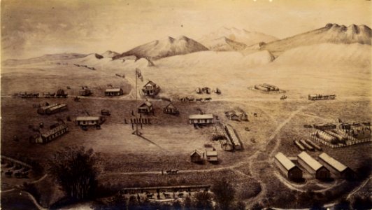
colorado
history
science
etc
charleroi on maps of popp
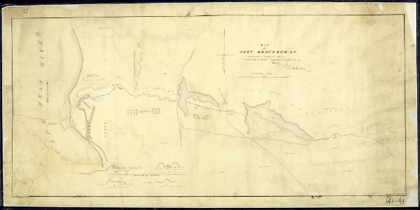
everett d. graff collection of western americana
maps by g. w. & c. b. colton & co.
historical
history
charleroi on maps of popp
couillet
18th-century maps of ireland
old maps of dublin
charles william meredith van de velde
eran laor cartographic collection
charleroi on maps of popp
lodelinsart
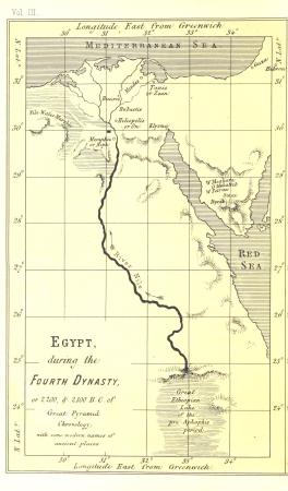
life and work at the great pyramid (1867)
maps of the egyptian old kingdom
gemeente atlas van nederland - gelderland
maps of barneveld
life and work at the great pyramid (1867)
19th-century maps of the nile river
place de la digue (charleroi)
charleroi on maps of popp
history
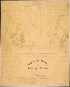
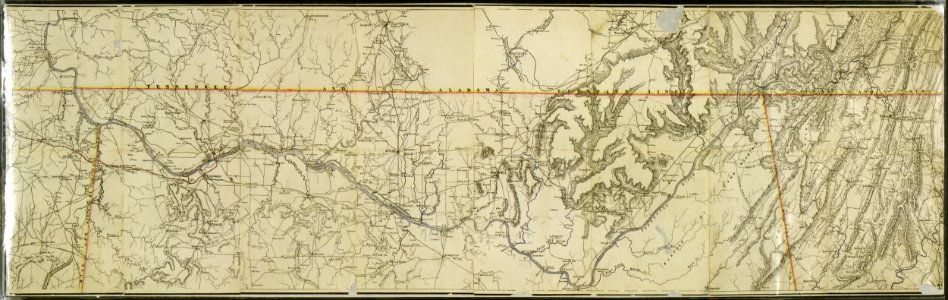
alabama
historical
history
historical
history
historical
history
historical
history
historical
history
historical
history
historical
history
life and work at the great pyramid (1867)
life and work at the great pyramid (1867)
drawings by bramine hubrecht in the rijksmuseum amsterdam
black chalk drawings in the rijksmuseum amsterdam
301 - 400 of 583
Next page
/ 6


![[Tours in the United States by famous American actors and actresses, 1865-1904]., Joseph Jefferson, 1935](https://cdn.creazilla.com/illustrations/10000909370/tours-in-the-united-states-by-famous-american-actors-and-actresses-1865-1904-joseph-jefferson-1935-md.jpg)
![[Tours in the United States by famous American actors and actresses, 1865-1904]., Joseph Jefferson, 1935](https://cdn.creazilla.com/illustrations/10001594868/tours-in-the-united-states-by-famous-american-actors-and-actresses-1865-1904-joseph-jefferson-1935-md.jpg)